


the Flume, F
It was raining this morning. It was a light rain, more a drizzle, but it was wet, cold, and overcast. Perfect weather for photography and hiking? No. Still, we drove north from Country Bumpkins Campground toward Franconia to check the area out and drive through some of the local towns. Going north we saw the turn-out for The Flume ahead and I turned in. I remember visiting this landmark with mom and dad when I was barely a teenager. I figured we could visit the information center, get some info, and continue north.
The information center has changed! Not only is it the entry to the state park, but it has a souvenir shop AND a restaurant! It is much more developed than I remember fifty years ago. It was still raining and/or spitting when we entered the information center. We looked around some then went to the information desk. Ellen asked a disarming question, not your typical how long how far sort of thing, and we immediately had rapport. Ellen asked about tomorrow’s weather and it did not look good. Today was the better day to walk The Flume.
We went back to The Beast and changed for rain. While we were changing, the sun popped out from behind a cloud. Great! We headed in to buy tickets. We delayed taking photos out front and delayed sufficiently for a bus load of “tourists” to head in behind us. Now don’t get me wrong, we are all “tourists”, it’s just that I hate being trapped in a sea of people disgorged from a bus. There can be fifty or a hundred people milling about. It makes photography challenging.

After we got our tickets we filed to the entrance to the 2 mile walk along with the bus load just as a torrent of rain fell. The bus load waited under the eves, we pushed past as the rain diminished and started our walk.
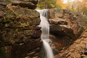
If you are visiting the Franconia Notch area, visit The Flume. It is exhilarating to be out doors and walking. If you enjoy photography, the contract between shadow and sunlight makes for challenging photography, and the flume is an amazing geological formation.

We dawdled at the first covered bridge long enough for “the hoard” to catch up. We continued to dawdle and never saw them again. The two mile walk typically takes an hour. It took us 2 1/2-3 hours as we enjoyed our walk through forest then along a gorge and by a waterfall. About half way through our walk the rain subsided and the sun poked through the clouds. What joy! We took our time meandering through the park and soaking in the streaming sunshine.
We were told it would take about an hour to walk the Flume. It took us a bit over four hours. We walked, talked, explored Ellen’s camera features, and had a blast. It was past four pm when we arrived at the gift shop/restaurant for a hot dog. They were just ok. The ones at the cog railway are much better. We stopped by the gift shop and saw the same balsam sachets that were available at the top of Mt Washington. I considered getting one there, but the price was pretty high. On the way down the cog, I regretted my decision. The scent of balsam is so Christmasie. There they were and we took one away with us. It sits beside me now filling The Beast with the scent of fall and Christmas. It is wonderful.
As we were walking out we met Carl and Olivia coming in. They’re the Surrey couple we had met at Country Bumpkins. They went to Echo Lake before heading here. I asked if there was an echo and Carl admitted they didn’t want to make a spectacle of themselves and had not tried.
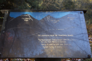
We went looking for the towns of Franconia, Lincoln, and Woodstock. Though the towns were founded in the 1700’s, none are particularly memorable. There is an Iron works in Franconia that is noteworthy, though the town lacks the charm of Littleton or the industry of St Johnsburg. We went back to our campsite at Country Bumpkins.
I highly recommend stopping at Country Bumpkins if you are looking for a campsite in Lincoln New Hampshire. This is our second evening here. We changed sites as the one we were at is reserved for this evening. At our new site, we have a good view to the south for sat reception, but the electric box and the water spigot are about thirty five feet apart! We have the hose and electric cable to make this happen. Still it is a strange setup. After connecting and checking level, I fired up the Winegard Sat Antenna. IT buzzed and whirred for a very long time before settling on the satellites. OK. The DirecTV receiver saw a problem connecting to the antenna. There was a small tree directly in the path the antenna had selected for sat reception. No Problem. I’ll just pull back about a foot and that should move the tree out of the way. Trouble is, we had very little slack in the water hose. Backing up a foot is possible, but not two feet. With Ellen’s help, we backed up a foot and sat reception is all good.

This evening we took long showers, luxurious shower at the campsite. There are only four showers, 2 men’s and 2 women’s. They have those old dorm shower heads that are usually not so good, but with the water pressure they have, it was great. Also their internet access is quite fast. At other campsites I’ve seen transfer rates as low as 180 Kbps. At Country Bumpkin bursts of 2.4 Mbps are not unusual.
Tomorrow we may head off on a side-trip to meet with Walt. Walt lives in Lebanon NH. We’ll chose someplace roughly mid-way and spend a day before heading east to Conway NH. We have a rendezvous with a zip line on the way.
If I have not mentioned it before, Ellen is getting to know her new camera. At least half of the photos posted on our blog since we left for New England are her’s. I’m encouraging her to use manual to learn how to handle difficult light situations where auto just cannot cut-it. Her camera has so many modes and options that it will take some time to be comfortable with all its features.


If you are in the Mt Washington State Park in New Hampshire, you would do well to take a ride on the Cog Railway to the top of Mt Washington. Do this on a clear day, and you will be rewarded with some of the most magnificent vistas east of the Mississippi. Be warned Mt Washington creates its own weather. It may be warm at the base station and it could be snowing on top. Today it was 54 degrees in the sun at base and with wind chill, -11 degrees at the top!


Each day one steam driven train sets out at 9:15 am. The remaining trains are all bio-diesel. The steam train was booked for today, 10/15. We figured the other trains couldn’t be booked, it was after Columbus Day after all. We left at a comfortable time this morning, around 9:30, which is early for us.


We drove the 12 miles from Ammonoosuc Campgrounds to the cog base station. The base station road runs east from 302. We had been warned that some GPS units will route you to the wrong side of Mt Washington! We saw practically no other vehicle on our drive to the station. Parking was easy, though I was surprised at the number of cars. We parked in the third lot down from upper parking! At the ticket office we were told, “I can get you on the 2:30 train.” ??? It was 10:10 am. The Cog Railway was BUSY! The gal said, “Oh wait, I can get you two on the 12:30, be at platform A at 12:00”. Now I would recommend ordering tickets ahead of time on-line. The Cog Railway: more information

Two hours can make a huge difference. At 10 am the skies were clear, it was cold in the shade with a bit of a breeze at the base. The weather in the presidential range is notorious, it can change drastically in a few hours. The world recorded wind speed of 253 MPH was set in 2010 on the top of Mt Washington. The mountain creates its own weather.


Mt Washington’s cog railway is the first one built in the world. It runs from the base at 2100 feet to the top at 6288 feet. It has an average grade of 25% with a maximum of 37.4%. It was first operational in 1868 and has been in constant operation since, but with regularly upgraded equipment. still more information
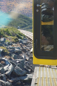

We explored the train station, walked around outside, and had lunch at the restaurant. In the museum we saw a very interesting video loop describing the history of the railway and the technology. Delayed, we were far back in the embarkation line and sat toward the back of the single car. There are no bad seats, though the seats at the front of the car both ascending and descending are the best. The car brakeman, Andrew, regaled us with stories and jokes about the railway, the car’s design, the tracks, and sights we passed. He mentioned that New Hampshire’s famous “the Old Man in the Mountain” collapsed. His name was changed to “Cliff”. see this composite image

The ride to the top goes quickly. It does not feel like an hour ride. About half way up the tracks double up and up and down bound trains pass each other. The air temperature grows much colder nearer the top and the wind picks up on the ridge.


When we left the base it was 54 degrees. At the top the temp was -11 with wind chill. It was cold. The warming hut I thought I remembered from 40 years ago, is no more. Perhaps I’m remembering the Tip Top Hut. Today there is a large warm building that houses a restaurant, a gift shop, and a hiker’s information desk. We headed inside right away waiting for the crowd outside to disperse; some boarding the trains back down the mountain, others milling about until the cold got the better of them. In a short time we went back outside to explore in relative peace.


We saw a glider decouple from its plane and soar below us. We marveled at the vista of fall colors. The trees to the north were past peak while the trees to the south looked to be peaking. There was significantly more red color to the south.


We were freezing. We popped into a small hut to warm up and found ourselves in a small souvenir nut. The scent of pine filled the hut. Ellen found a sweat shirt she liked and I came very close to buying a balsam pillow. Once we warmed up, we headed back to the main building for cocoa and apple cider. The hiker’s desk was not busy. I asked about Tuckerman’s Ravine and we were off. Kevin and I discussed Tuckerman’s, skiing Mt Washington, the east coast, Tahoe, new skis designs, snow quality. We had a great time until we noticed the queue for the train down the mountain. This time we were at the end of the line and were separated on the ride down. It was no problem, Ellen sat behind me and often warmed my ears. There really is no bad seat on the car. The views on the way down were stellar. The skies were clear, though we had seen clouds blowing past the mountain top.


We thawed out at the bottom, both agreeing that this day was “awesome”. Remembering the chili the restaurant served for lunch, we visited the base station restaurant to find gaping holes in the counter where the soup and chili pots had been. No Problem, the counter guy said, we have lots. We bought two pints to heat for dinner later. Next, in the gift shop I mentioned in an off hand way that I’d like to see a moose in the flesh. A local standing beside me told me where I might find some Moose, their habits, and Ellen mentioned the declining moose population caused by ticks. We were off on a wide ranging discussion about: climate change, life style, ticks (his dog never had an issue with ticks until three years ago, now he sees deer ticks all the time, some moose have over a thousand ticks on them and they’re anemic) and population growth as the cause of “it all”. People have the time to stop and engage in conversation here. Is it just New York and New England? I’ll pay closer attention as we work our way back west in four or six weeks.
We headed toward Franconia Notch thinking we could get south of the notch and setup camp before nightfall. On the way we stopped at a road-side outlook.


There are a number of campsites in and around the notch and more than a few to the north and south. We settled on “Country Bumpkins” in Lincoln. They are open through the end of October (the owner said; not really, they close next week). They have a variety of options for hookups from full to electric only, they have WiFi, and cable.

Setting up camp is usually as simple as pushing an electric plug into a socket, screwing a water filter into a spigot, quick-connecting our water hose to the filter and to the RV, and pushing out the slide-out. In warmer weather we might pull out an outdoor mat, chairs, and a BBQ and unfurl the awning, but when it’s cold less is more. In the cold we are quickly mobile; breaking camp can be done in a flash.
As usual, we drove past the campsite, turned around, and checked in. There was a couple from England ahead of us. Carl and his GF flew from Surrey to Boston and rented an RV for two weeks to tour New Hampshire and Massachusetts. We had a good time talking about our trips, his work (an architect), and the future. Carl was fascinated to think that he could just drop everything and be an RV nomad full time. He’s been bitten by the romance of the open road and the beauty of New England in the fall.

We’re now snug in The Beast, the heater is workin’ away,
Up the next morning to the patter of light rain. It’s overcast but not raining now. We’ll stay another day at Country Bumpkin Campground. The site we were at last night, #38, is taken tonight. Amy wrote out a list of available sites, we walked the campground and chose #26. 26 has a clear view to the south.
Amy is a warm caring woman. She’s fun and it is easy to while away half an hour simply chatting with her. Amy’s warmth extends to the campground. It is nestled in a small wooded valley with a creek flowing through the campground that flows into a river. They have Country Bumpkin photo walls. You know the type, a painting of two or three people with oval head cut-outs. You put your head in the oval and you’ve got your very own country bumpkin photo. The campground office closes at 9 pm; quite late for an RV campground. The campground is closing for the year this Sunday, 10/18, with no overnight camping on Sunday. Campground availability is closing down.
Amy said she and her family stay year-round. She starts taking reservations for 2016 in January.
Today we’ll visit the towns of Franconia, Lincoln and Woodstock, maybe take the walk to The Flume weather permitting.
We’re staying with Paul, Carolann, and Dylan here in Syracuse NY, Carolann is Ellen’s sister. We’ve had wide ranging conversations about politics, family, music, and local issues that’s been fun for all. The driving through Pennsylvania and into New York, the weather turned overcast and rain has fallen off and on since we arrived and is expected to continue for the next few days. There has been extensive flooding along the East Coast of the Carolinas and Maryland and with Tropical Storm (hurricane?) Joaquin on the way we could see more extensive rain.
We’re planning to push on to visit DeDe and Don in Pine Plains, but some of the roads into the woods are dirt and prone to flooding. We’ll drive to Tivoli, drop off Li’l Beast, and ride to Pine Plains with David and Chris.
Paul said last night that it had been unusually dry the past few months. This rain is the first they’ve had in quite a while and that the dryness influences the fall foliage. The leaves turn “all at once” and fall from the trees! I did notice just this happening in Pennsylvania and parts of New York where some trees had turned and dropped most of their leaves. They were not maples though.
We went to the Empire Brewing Company for dinner last night. The brewery was originally a Cajun and Creole restaurant. The brewery’s menu retained the Cajun and Creole flair. Ellen had the lobster bisque and a fabulous three meat chili of Elk, Angus, and Kobe. Paul and Carolann shared a cajun dish of jambolaya and gumbo. Their IPA was goooood.
I was born and raised near Boston, Mass. As a child and young teenager my family would take weekend trips to Vermont and New Hampshire and visit their natural wonders. I remember more of New Hampshire, probably because we spent more time there. It will be fun for me to revisit some of the outstanding places I remember and discover some new ones along the way.
I recall being “out in the boonies” on our trips to Vermont. Forty years ago, Vermont was sparsely populated, rugged, and beautiful in an undeveloped sort of way. My guess is it has changed over the years. Some of the resources I’ll be using to plan our trip through Vermont are:
Franconia Notch State Park, New Hampshire, closed Sept 19th. Luckily the Flume and Canon Mountain Tramway are open through Oct 25th and Oct 18th respectively. The White Mountain Cog Railway stays open through October.
Check these links for more information:
Just a short post to catch up.
Ron